|
|
|||||||||||||||||
| Point ID: 2830 | Downloads | Plots | Site Data | Code: 05LJ020 |
|
|
|||||||||||||||||
| Download | |
|---|---|
| Site Descriptor Information | Site Time Series Data |
| Link to all available data | |
| View: | Time Series | All |
| Units: | mm |
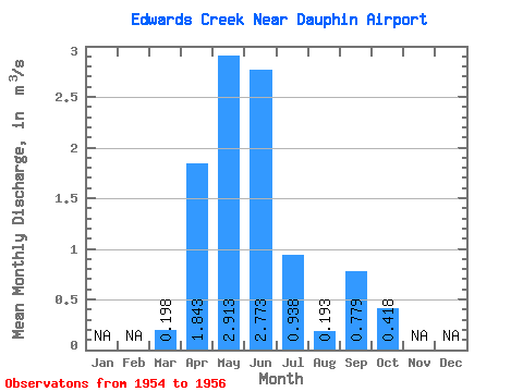
| Statistic | Jan | Feb | Mar | Apr | May | Jun | Jul | Aug | Sep | Oct | Nov | Dec | Annual |
|---|---|---|---|---|---|---|---|---|---|---|---|---|---|
| Mean | 0.20 | 1.84 | 2.91 | 2.77 | 0.94 | 0.19 | 0.78 | 0.42 | |||||
| Standard Deviation | 0.66 | 0.90 | 0.24 | 0.60 | 0.08 | 1.17 | 0.55 | ||||||
| Min | 0.20 | 1.37 | 1.97 | 2.52 | 0.33 | 0.10 | 0.02 | 0.06 | |||||
| Max | 0.20 | 2.60 | 3.76 | 3.01 | 1.54 | 0.24 | 2.13 | 1.05 | |||||
| Coefficient of Variation | 0.36 | 0.31 | 0.09 | 0.64 | 0.42 | 1.51 | 1.31 |
 Return to R-Arctic Net Home Page