|
|
| Point ID: 2830 | Downloads | Plots | Site Data | Code: 05LJ020 |
|
| Download | |
|---|---|
| Site Descriptor Information | Site Time Series Data |
| Link to all available data | |
|
|
|
| View: | Statistics | All |
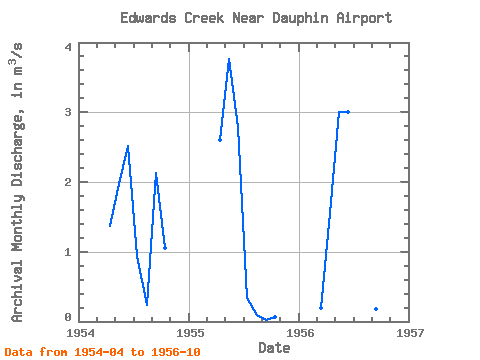
| Units: | mm |
| Year | Jan | Feb | Mar | Apr | May | Jun | Jul | Aug | Sep | Oct | Nov | Dec | Annual | 1954 | 1.37 | 1.97 | 2.52 | 0.94 | 0.24 | 2.13 | 1.05 | 1955 | 2.60 | 3.76 | 2.79 | 0.33 | 0.10 | 0.02 | 0.06 | 1956 | 0.20 | 1.56 | 3.01 | 3.01 | 1.54 | 0.24 | 0.19 | 0.14 |
|---|
 Return to R-Arctic Net Home Page