|
|
|||||||||||||||||
| Point ID: 2827 | Downloads | Plots | Site Data | Code: 05LJ017 |
|
|
|||||||||||||||||
| Download | |
|---|---|
| Site Descriptor Information | Site Time Series Data |
| Link to all available data | |
| View: | Time Series | All |
| Units: | mm |
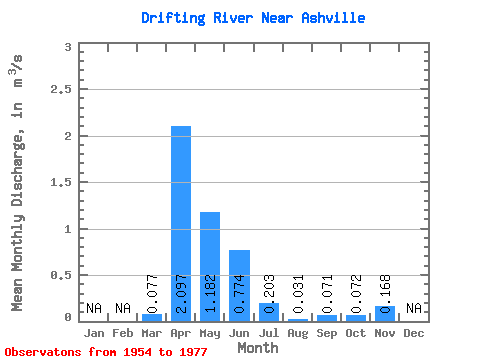
| Statistic | Jan | Feb | Mar | Apr | May | Jun | Jul | Aug | Sep | Oct | Nov | Dec | Annual |
|---|---|---|---|---|---|---|---|---|---|---|---|---|---|
| Mean | 0.08 | 2.10 | 1.18 | 0.77 | 0.20 | 0.03 | 0.07 | 0.07 | 0.17 | ||||
| Standard Deviation | 0.13 | 1.66 | 1.51 | 1.32 | 0.38 | 0.07 | 0.18 | 0.17 | 0.15 | ||||
| Min | 0.00 | 0.02 | 0.01 | 0.00 | 0.00 | 0.00 | 0.00 | 0.00 | 0.00 | ||||
| Max | 0.47 | 4.60 | 5.77 | 4.97 | 1.86 | 0.28 | 0.65 | 0.67 | 0.29 | ||||
| Coefficient of Variation | 1.65 | 0.79 | 1.28 | 1.71 | 1.89 | 2.23 | 2.49 | 2.29 | 0.89 |
 Return to R-Arctic Net Home Page