|
|
|||||||||||||||||
| Point ID: 2827 | Downloads | Plots | Site Data | Code: 05LJ017 |
|
|
|||||||||||||||||
| Download | |
|---|---|
| Site Descriptor Information | Site Time Series Data |
| Link to all available data | |
| View: | Time Series | All |
| Units: | m3/s |
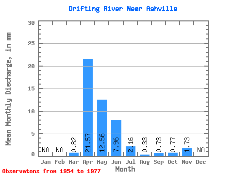
| Statistic | Jan | Feb | Mar | Apr | May | Jun | Jul | Aug | Sep | Oct | Nov | Dec | Annual |
|---|---|---|---|---|---|---|---|---|---|---|---|---|---|
| Mean | 0.81 | 21.57 | 12.56 | 7.96 | 2.15 | 0.33 | 0.73 | 0.77 | 1.73 | ||||
| Standard Deviation | 1.34 | 17.09 | 16.03 | 13.61 | 4.07 | 0.73 | 1.82 | 1.76 | 1.55 | ||||
| Min | 0.00 | 0.17 | 0.16 | 0.00 | 0.00 | 0.00 | 0.00 | 0.00 | 0.01 | ||||
| Max | 4.94 | 47.31 | 61.32 | 51.12 | 19.77 | 2.94 | 6.70 | 7.09 | 3.00 | ||||
| Coefficient of Variation | 1.65 | 0.79 | 1.28 | 1.71 | 1.89 | 2.23 | 2.49 | 2.29 | 0.89 |
 Return to R-Arctic Net Home Page