|
|
|||||||||||||||||
| Point ID: 2821 | Downloads | Plots | Site Data | Code: 05LJ011 |
|
|
|||||||||||||||||
| Download | |
|---|---|
| Site Descriptor Information | Site Time Series Data |
| Link to all available data | |
| View: | Time Series | All |
| Units: | mm |
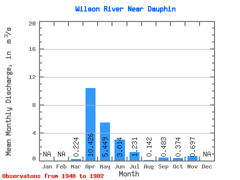
| Statistic | Jan | Feb | Mar | Apr | May | Jun | Jul | Aug | Sep | Oct | Nov | Dec | Annual |
|---|---|---|---|---|---|---|---|---|---|---|---|---|---|
| Mean | 0.22 | 10.43 | 5.45 | 3.01 | 1.23 | 0.14 | 0.48 | 0.37 | 0.70 | ||||
| Standard Deviation | 0.53 | 7.72 | 6.98 | 4.92 | 2.20 | 0.21 | 1.58 | 0.76 | 0.50 | ||||
| Min | 0.00 | 0.00 | 0.05 | 0.00 | 0.00 | 0.00 | 0.00 | 0.00 | 0.34 | ||||
| Max | 2.61 | 32.90 | 28.30 | 24.10 | 9.82 | 0.88 | 8.75 | 2.66 | 1.05 | ||||
| Coefficient of Variation | 2.37 | 0.74 | 1.28 | 1.63 | 1.79 | 1.46 | 3.27 | 2.04 | 0.72 |
 Return to R-Arctic Net Home Page