|
|
|||||||||||||||||
| Point ID: 2821 | Downloads | Plots | Site Data | Code: 05LJ011 |
|
|
|||||||||||||||||
| Download | |
|---|---|
| Site Descriptor Information | Site Time Series Data |
| Link to all available data | |
| View: | Time Series | All |
| Units: | m3/s |
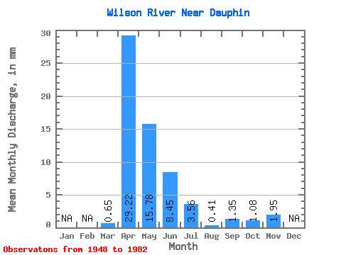
| Statistic | Jan | Feb | Mar | Apr | May | Jun | Jul | Aug | Sep | Oct | Nov | Dec | Annual |
|---|---|---|---|---|---|---|---|---|---|---|---|---|---|
| Mean | 0.65 | 29.22 | 15.78 | 8.45 | 3.56 | 0.41 | 1.35 | 1.08 | 1.95 | ||||
| Standard Deviation | 1.53 | 21.64 | 20.21 | 13.77 | 6.36 | 0.60 | 4.43 | 2.21 | 1.40 | ||||
| Min | 0.00 | 0.00 | 0.15 | 0.00 | 0.00 | 0.00 | 0.00 | 0.00 | 0.96 | ||||
| Max | 7.56 | 92.19 | 81.93 | 67.53 | 28.43 | 2.54 | 24.52 | 7.70 | 2.94 | ||||
| Coefficient of Variation | 2.37 | 0.74 | 1.28 | 1.63 | 1.79 | 1.46 | 3.27 | 2.04 | 0.72 |
 Return to R-Arctic Net Home Page