|
|
|||||||||||||||||
| Point ID: 2820 | Downloads | Plots | Site Data | Code: 05LJ010 |
|
|
|||||||||||||||||
| Download | |
|---|---|
| Site Descriptor Information | Site Time Series Data |
| Link to all available data | |
| View: | Time Series | All |
| Units: | mm |
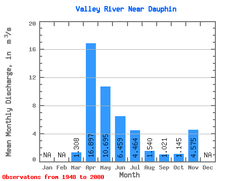
| Statistic | Jan | Feb | Mar | Apr | May | Jun | Jul | Aug | Sep | Oct | Nov | Dec | Annual |
|---|---|---|---|---|---|---|---|---|---|---|---|---|---|
| Mean | 1.31 | 16.90 | 10.70 | 6.46 | 4.46 | 1.54 | 1.02 | 1.15 | 4.58 | ||||
| Standard Deviation | 1.54 | 13.22 | 12.91 | 8.77 | 5.72 | 2.14 | 1.73 | 1.79 | 0.05 | ||||
| Min | 0.00 | 1.10 | 0.58 | 0.08 | 0.00 | 0.00 | 0.00 | 0.00 | 4.54 | ||||
| Max | 7.14 | 61.00 | 62.50 | 44.60 | 24.80 | 12.10 | 9.27 | 11.20 | 4.61 | ||||
| Coefficient of Variation | 1.18 | 0.78 | 1.21 | 1.36 | 1.28 | 1.39 | 1.70 | 1.56 | 0.01 |
 Return to R-Arctic Net Home Page