|
|
|||||||||||||||||
| Point ID: 2820 | Downloads | Plots | Site Data | Code: 05LJ010 |
|
|
|||||||||||||||||
| Download | |
|---|---|
| Site Descriptor Information | Site Time Series Data |
| Link to all available data | |
| View: | Time Series | All |
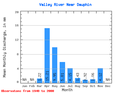
| Units: | m3/s |
| Statistic | Jan | Feb | Mar | Apr | May | Jun | Jul | Aug | Sep | Oct | Nov | Dec | Annual |
|---|---|---|---|---|---|---|---|---|---|---|---|---|---|
| Mean | 1.22 | 15.21 | 9.95 | 5.81 | 4.15 | 1.43 | 0.92 | 1.06 | 4.12 | ||||
| Standard Deviation | 1.43 | 11.90 | 12.00 | 7.90 | 5.32 | 1.99 | 1.56 | 1.66 | 0.04 | ||||
| Min | 0.00 | 0.99 | 0.54 | 0.07 | 0.00 | 0.00 | 0.00 | 0.00 | 4.09 | ||||
| Max | 6.64 | 54.90 | 58.12 | 40.14 | 23.06 | 11.25 | 8.34 | 10.41 | 4.15 | ||||
| Coefficient of Variation | 1.18 | 0.78 | 1.21 | 1.36 | 1.28 | 1.39 | 1.70 | 1.56 | 0.01 |
 Return to R-Arctic Net Home Page