|
|
|||||||||||||||||
| Point ID: 282 | Downloads | Plots | Site Data | Code: 05BH003 |
|
|
|||||||||||||||||
| Download | |
|---|---|
| Site Descriptor Information | Site Time Series Data |
| Link to all available data | |
| View: | Time Series | All |
| Units: | mm |
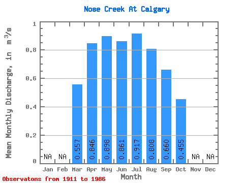
| Statistic | Jan | Feb | Mar | Apr | May | Jun | Jul | Aug | Sep | Oct | Nov | Dec | Annual |
|---|---|---|---|---|---|---|---|---|---|---|---|---|---|
| Mean | 0.56 | 0.85 | 0.90 | 0.86 | 0.92 | 0.81 | 0.66 | 0.46 | |||||
| Standard Deviation | 0.79 | 0.96 | 1.26 | 1.53 | 2.13 | 2.17 | 1.40 | 0.92 | |||||
| Min | 0.03 | 0.08 | 0.06 | 0.03 | 0.02 | 0.01 | 0.01 | 0.01 | |||||
| Max | 2.46 | 3.82 | 5.14 | 5.36 | 8.84 | 9.75 | 5.96 | 3.60 | |||||
| Coefficient of Variation | 1.43 | 1.14 | 1.41 | 1.78 | 2.33 | 2.69 | 2.12 | 2.03 |
 Return to R-Arctic Net Home Page