|
|
|||||||||||||||||
| Point ID: 2818 | Downloads | Plots | Site Data | Code: 05LJ005 |
|
|
|||||||||||||||||
| Download | |
|---|---|
| Site Descriptor Information | Site Time Series Data |
| Link to all available data | |
| View: | Time Series | All |
| Units: | mm |
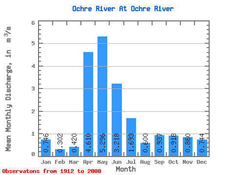
| Statistic | Jan | Feb | Mar | Apr | May | Jun | Jul | Aug | Sep | Oct | Nov | Dec | Annual |
|---|---|---|---|---|---|---|---|---|---|---|---|---|---|
| Mean | 0.75 | 0.30 | 0.42 | 4.61 | 5.30 | 3.22 | 1.69 | 0.60 | 0.94 | 0.92 | 0.86 | 0.74 | 1.20 |
| Standard Deviation | 1.24 | 0.52 | 0.44 | 2.85 | 4.22 | 3.46 | 1.77 | 0.71 | 2.47 | 0.88 | 1.02 | 1.30 | 0.62 |
| Min | 0.00 | 0.00 | 0.00 | 0.82 | 0.56 | 0.04 | 0.02 | 0.00 | 0.01 | 0.17 | 0.16 | 0.03 | 0.69 |
| Max | 2.18 | 0.91 | 1.82 | 13.00 | 18.60 | 16.60 | 8.13 | 4.32 | 19.90 | 4.40 | 3.82 | 2.69 | 1.89 |
| Coefficient of Variation | 1.67 | 1.73 | 1.04 | 0.62 | 0.80 | 1.07 | 1.05 | 1.19 | 2.63 | 0.96 | 1.18 | 1.75 | 0.51 |
 Return to R-Arctic Net Home Page