|
|
|||||||||||||||||
| Point ID: 2818 | Downloads | Plots | Site Data | Code: 05LJ005 |
|
|
|||||||||||||||||
| Download | |
|---|---|
| Site Descriptor Information | Site Time Series Data |
| Link to all available data | |
| View: | Time Series | All |
| Units: | m3/s |
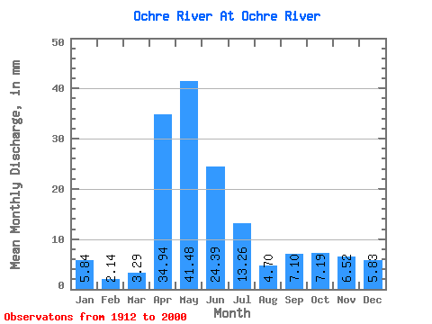
| Statistic | Jan | Feb | Mar | Apr | May | Jun | Jul | Aug | Sep | Oct | Nov | Dec | Annual |
|---|---|---|---|---|---|---|---|---|---|---|---|---|---|
| Mean | 5.84 | 2.15 | 3.29 | 34.94 | 41.47 | 24.39 | 13.26 | 4.70 | 7.11 | 7.19 | 6.52 | 5.82 | 110.93 |
| Standard Deviation | 9.73 | 3.73 | 3.42 | 21.61 | 33.06 | 26.23 | 13.88 | 5.57 | 18.70 | 6.88 | 7.71 | 10.17 | 57.06 |
| Min | 0.00 | 0.00 | 0.00 | 6.23 | 4.35 | 0.31 | 0.16 | 0.00 | 0.07 | 1.36 | 1.23 | 0.23 | 63.80 |
| Max | 17.07 | 6.46 | 14.25 | 98.53 | 145.65 | 125.81 | 63.66 | 33.83 | 150.82 | 34.45 | 28.95 | 21.06 | 174.36 |
| Coefficient of Variation | 1.67 | 1.73 | 1.04 | 0.62 | 0.80 | 1.07 | 1.05 | 1.19 | 2.63 | 0.96 | 1.18 | 1.75 | 0.51 |
 Return to R-Arctic Net Home Page