|
|
|||||||||||||||||
| Point ID: 2811 | Downloads | Plots | Site Data | Code: 05LG006 |
|
|
|||||||||||||||||
| Download | |
|---|---|
| Site Descriptor Information | Site Time Series Data |
| Link to all available data | |
| View: | Time Series | All |
| Units: | mm |
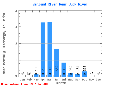
| Statistic | Jan | Feb | Mar | Apr | May | Jun | Jul | Aug | Sep | Oct | Nov | Dec | Annual |
|---|---|---|---|---|---|---|---|---|---|---|---|---|---|
| Mean | 0.18 | 3.25 | 3.31 | 1.66 | 0.85 | 0.26 | 0.18 | 0.32 | |||||
| Standard Deviation | 0.22 | 2.51 | 3.28 | 1.73 | 1.48 | 0.37 | 0.27 | 0.34 | |||||
| Min | 0.00 | 0.42 | 0.35 | 0.01 | 0.04 | 0.00 | 0.00 | 0.00 | |||||
| Max | 1.02 | 10.10 | 13.50 | 6.61 | 7.22 | 1.29 | 1.03 | 1.53 | |||||
| Coefficient of Variation | 1.21 | 0.77 | 0.99 | 1.04 | 1.74 | 1.45 | 1.50 | 1.07 |
 Return to R-Arctic Net Home Page