|
|
|||||||||||||||||
| Point ID: 2811 | Downloads | Plots | Site Data | Code: 05LG006 |
|
|
|||||||||||||||||
| Download | |
|---|---|
| Site Descriptor Information | Site Time Series Data |
| Link to all available data | |
| View: | Time Series | All |
| Units: | m3/s |
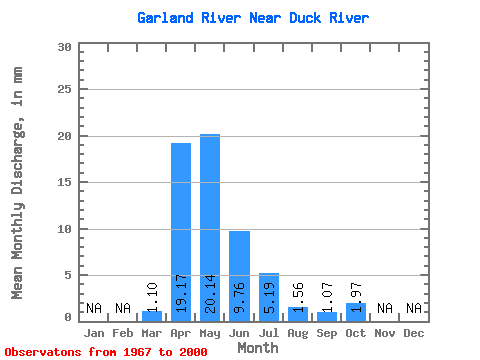
| Statistic | Jan | Feb | Mar | Apr | May | Jun | Jul | Aug | Sep | Oct | Nov | Dec | Annual |
|---|---|---|---|---|---|---|---|---|---|---|---|---|---|
| Mean | 1.10 | 19.18 | 20.14 | 9.76 | 5.18 | 1.57 | 1.06 | 1.96 | |||||
| Standard Deviation | 1.32 | 14.77 | 19.94 | 10.16 | 9.02 | 2.27 | 1.60 | 2.10 | |||||
| Min | 0.00 | 2.50 | 2.12 | 0.06 | 0.25 | 0.01 | 0.00 | 0.00 | |||||
| Max | 6.21 | 59.50 | 82.17 | 38.94 | 43.94 | 7.85 | 6.07 | 9.31 | |||||
| Coefficient of Variation | 1.21 | 0.77 | 0.99 | 1.04 | 1.74 | 1.45 | 1.50 | 1.07 |
 Return to R-Arctic Net Home Page