|
|
|||||||||||||||||
| Point ID: 2808 | Downloads | Plots | Site Data | Code: 05LG003 |
|
|
|||||||||||||||||
| Download | |
|---|---|
| Site Descriptor Information | Site Time Series Data |
| Link to all available data | |
| View: | Time Series | All |
| Units: | mm |
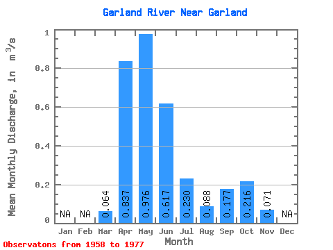
| Statistic | Jan | Feb | Mar | Apr | May | Jun | Jul | Aug | Sep | Oct | Nov | Dec | Annual |
|---|---|---|---|---|---|---|---|---|---|---|---|---|---|
| Mean | 0.06 | 0.84 | 0.98 | 0.62 | 0.23 | 0.09 | 0.18 | 0.22 | 0.07 | ||||
| Standard Deviation | 0.06 | 0.53 | 0.89 | 0.49 | 0.36 | 0.08 | 0.21 | 0.22 | |||||
| Min | 0.00 | 0.10 | 0.11 | 0.01 | 0.01 | 0.00 | 0.00 | 0.02 | 0.07 | ||||
| Max | 0.23 | 2.00 | 2.97 | 1.47 | 1.39 | 0.31 | 0.82 | 0.86 | 0.07 | ||||
| Coefficient of Variation | 0.87 | 0.63 | 0.91 | 0.79 | 1.55 | 0.95 | 1.17 | 1.02 |
 Return to R-Arctic Net Home Page