|
|
|||||||||||||||||
| Point ID: 2808 | Downloads | Plots | Site Data | Code: 05LG003 |
|
|
|||||||||||||||||
| Download | |
|---|---|
| Site Descriptor Information | Site Time Series Data |
| Link to all available data | |
| View: | Time Series | All |
| Units: | m3/s |
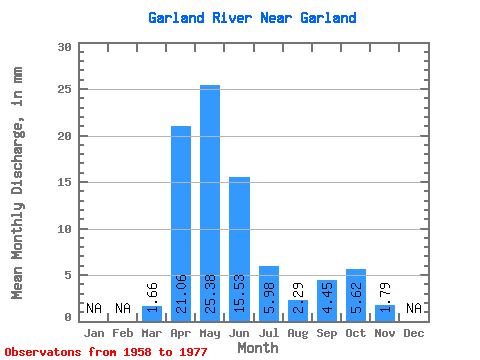
| Statistic | Jan | Feb | Mar | Apr | May | Jun | Jul | Aug | Sep | Oct | Nov | Dec | Annual |
|---|---|---|---|---|---|---|---|---|---|---|---|---|---|
| Mean | 1.67 | 21.05 | 25.38 | 15.53 | 5.99 | 2.28 | 4.46 | 5.62 | 1.79 | ||||
| Standard Deviation | 1.45 | 13.30 | 23.09 | 12.33 | 9.29 | 2.17 | 5.20 | 5.74 | |||||
| Min | 0.08 | 2.52 | 2.89 | 0.20 | 0.13 | 0.00 | 0.00 | 0.57 | 1.79 | ||||
| Max | 6.11 | 50.33 | 77.22 | 36.99 | 36.14 | 8.01 | 20.66 | 22.36 | 1.79 | ||||
| Coefficient of Variation | 0.87 | 0.63 | 0.91 | 0.79 | 1.55 | 0.95 | 1.17 | 1.02 |
 Return to R-Arctic Net Home Page