|
|
|||||||||||||||||
| Point ID: 2806 | Downloads | Plots | Site Data | Code: 05LG001 |
|
|
|||||||||||||||||
| Download | |
|---|---|
| Site Descriptor Information | Site Time Series Data |
| Link to all available data | |
| View: | Time Series | All |
| Units: | mm |
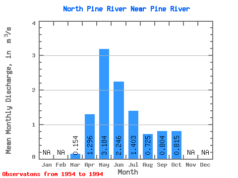
| Statistic | Jan | Feb | Mar | Apr | May | Jun | Jul | Aug | Sep | Oct | Nov | Dec | Annual |
|---|---|---|---|---|---|---|---|---|---|---|---|---|---|
| Mean | 0.15 | 1.30 | 3.18 | 2.25 | 1.40 | 0.72 | 0.80 | 0.81 | |||||
| Standard Deviation | 0.12 | 0.93 | 2.45 | 1.89 | 1.20 | 0.80 | 0.84 | 0.71 | |||||
| Min | 0.00 | 0.06 | 0.32 | 0.07 | 0.01 | 0.00 | 0.01 | 0.10 | |||||
| Max | 0.56 | 3.49 | 9.87 | 9.13 | 6.36 | 3.79 | 3.58 | 2.80 | |||||
| Coefficient of Variation | 0.76 | 0.72 | 0.77 | 0.84 | 0.85 | 1.10 | 1.04 | 0.87 |
 Return to R-Arctic Net Home Page