|
|
|||||||||||||||||
| Point ID: 2806 | Downloads | Plots | Site Data | Code: 05LG001 |
|
|
|||||||||||||||||
| Download | |
|---|---|
| Site Descriptor Information | Site Time Series Data |
| Link to all available data | |
| View: | Time Series | All |
| Units: | m3/s |
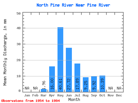
| Statistic | Jan | Feb | Mar | Apr | May | Jun | Jul | Aug | Sep | Oct | Nov | Dec | Annual |
|---|---|---|---|---|---|---|---|---|---|---|---|---|---|
| Mean | 1.97 | 16.00 | 40.60 | 27.72 | 17.89 | 9.24 | 9.92 | 10.39 | |||||
| Standard Deviation | 1.49 | 11.47 | 31.28 | 23.30 | 15.24 | 10.20 | 10.34 | 9.00 | |||||
| Min | 0.00 | 0.77 | 4.02 | 0.89 | 0.17 | 0.05 | 0.17 | 1.33 | |||||
| Max | 7.09 | 43.08 | 125.87 | 112.69 | 81.11 | 48.33 | 44.19 | 35.71 | |||||
| Coefficient of Variation | 0.76 | 0.72 | 0.77 | 0.84 | 0.85 | 1.10 | 1.04 | 0.87 |
 Return to R-Arctic Net Home Page