|
|
|||||||||||||||||
| Point ID: 2805 | Downloads | Plots | Site Data | Code: 05LF002 |
|
|
|||||||||||||||||
| Download | |
|---|---|
| Site Descriptor Information | Site Time Series Data |
| Link to all available data | |
| View: | Time Series | All |
| Units: | mm |
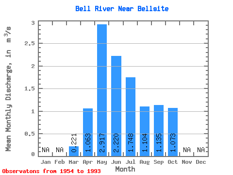
| Statistic | Jan | Feb | Mar | Apr | May | Jun | Jul | Aug | Sep | Oct | Nov | Dec | Annual |
|---|---|---|---|---|---|---|---|---|---|---|---|---|---|
| Mean | 0.22 | 1.06 | 2.92 | 2.22 | 1.75 | 1.10 | 1.14 | 1.07 | |||||
| Standard Deviation | 0.08 | 0.70 | 2.15 | 1.66 | 1.40 | 0.90 | 0.82 | 0.81 | |||||
| Min | 0.06 | 0.18 | 0.39 | 0.23 | 0.14 | 0.13 | 0.14 | 0.17 | |||||
| Max | 0.48 | 2.56 | 9.83 | 7.56 | 7.39 | 4.71 | 3.31 | 4.31 | |||||
| Coefficient of Variation | 0.36 | 0.66 | 0.74 | 0.74 | 0.80 | 0.82 | 0.72 | 0.76 |
 Return to R-Arctic Net Home Page