|
|
|||||||||||||||||
| Point ID: 2805 | Downloads | Plots | Site Data | Code: 05LF002 |
|
|
|||||||||||||||||
| Download | |
|---|---|
| Site Descriptor Information | Site Time Series Data |
| Link to all available data | |
| View: | Time Series | All |
| Units: | m3/s |
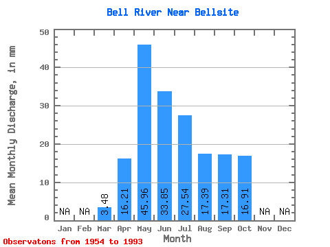
| Statistic | Jan | Feb | Mar | Apr | May | Jun | Jul | Aug | Sep | Oct | Nov | Dec | Annual |
|---|---|---|---|---|---|---|---|---|---|---|---|---|---|
| Mean | 3.48 | 16.21 | 45.95 | 33.85 | 27.53 | 17.40 | 17.31 | 16.90 | |||||
| Standard Deviation | 1.27 | 10.67 | 33.87 | 25.24 | 22.01 | 14.21 | 12.44 | 12.81 | |||||
| Min | 0.93 | 2.73 | 6.17 | 3.55 | 2.13 | 2.06 | 2.07 | 2.68 | |||||
| Max | 7.56 | 39.03 | 154.85 | 115.27 | 116.41 | 74.20 | 50.47 | 67.89 | |||||
| Coefficient of Variation | 0.36 | 0.66 | 0.74 | 0.74 | 0.80 | 0.82 | 0.72 | 0.76 |
 Return to R-Arctic Net Home Page