|
|
|||||||||||||||||
| Point ID: 2803 | Downloads | Plots | Site Data | Code: 05LE010 |
|
|
|||||||||||||||||
| Download | |
|---|---|
| Site Descriptor Information | Site Time Series Data |
| Link to all available data | |
| View: | Time Series | All |
| Units: | mm |
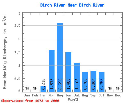
| Statistic | Jan | Feb | Mar | Apr | May | Jun | Jul | Aug | Sep | Oct | Nov | Dec | Annual |
|---|---|---|---|---|---|---|---|---|---|---|---|---|---|
| Mean | 0.22 | 1.57 | 2.59 | 1.49 | 1.10 | 0.76 | 0.80 | 0.75 | |||||
| Standard Deviation | 0.10 | 1.27 | 2.08 | 1.18 | 1.17 | 0.73 | 0.62 | 0.47 | |||||
| Min | 0.07 | 0.20 | 0.34 | 0.28 | 0.13 | 0.12 | 0.17 | 0.17 | |||||
| Max | 0.55 | 4.30 | 6.90 | 4.44 | 5.30 | 2.46 | 2.52 | 2.15 | |||||
| Coefficient of Variation | 0.46 | 0.81 | 0.81 | 0.79 | 1.06 | 0.96 | 0.77 | 0.62 |
 Return to R-Arctic Net Home Page