|
|
|||||||||||||||||
| Point ID: 2803 | Downloads | Plots | Site Data | Code: 05LE010 |
|
|
|||||||||||||||||
| Download | |
|---|---|
| Site Descriptor Information | Site Time Series Data |
| Link to all available data | |
| View: | Time Series | All |
| Units: | m3/s |
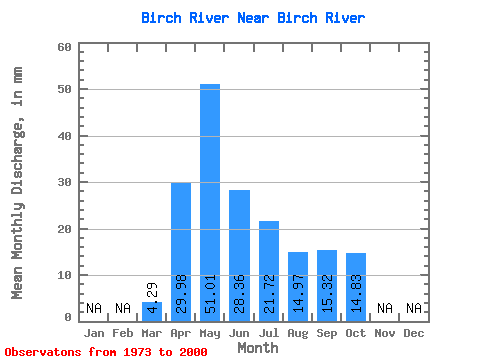
| Statistic | Jan | Feb | Mar | Apr | May | Jun | Jul | Aug | Sep | Oct | Nov | Dec | Annual |
|---|---|---|---|---|---|---|---|---|---|---|---|---|---|
| Mean | 4.29 | 29.98 | 51.00 | 28.36 | 21.72 | 14.96 | 15.32 | 14.84 | |||||
| Standard Deviation | 1.96 | 24.25 | 41.04 | 22.47 | 22.95 | 14.40 | 11.77 | 9.16 | |||||
| Min | 1.42 | 3.79 | 6.64 | 5.43 | 2.58 | 2.42 | 3.20 | 3.25 | |||||
| Max | 10.89 | 81.95 | 135.87 | 84.62 | 104.36 | 48.44 | 48.03 | 42.34 | |||||
| Coefficient of Variation | 0.46 | 0.81 | 0.81 | 0.79 | 1.06 | 0.96 | 0.77 | 0.62 |
 Return to R-Arctic Net Home Page