|
|
|||||||||||||||||
| Point ID: 2802 | Downloads | Plots | Site Data | Code: 05LE009 |
|
|
|||||||||||||||||
| Download | |
|---|---|
| Site Descriptor Information | Site Time Series Data |
| Link to all available data | |
| View: | Time Series | All |
| Units: | mm |
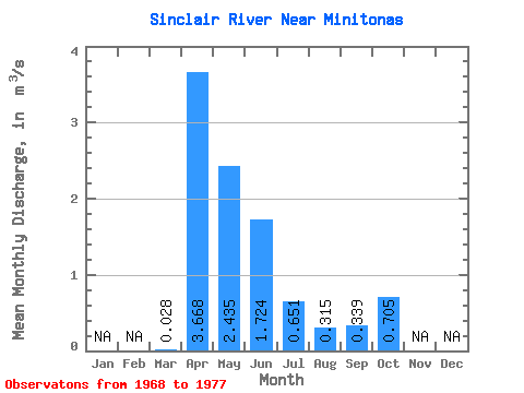
| Statistic | Jan | Feb | Mar | Apr | May | Jun | Jul | Aug | Sep | Oct | Nov | Dec | Annual |
|---|---|---|---|---|---|---|---|---|---|---|---|---|---|
| Mean | 0.03 | 3.67 | 2.44 | 1.72 | 0.65 | 0.32 | 0.34 | 0.70 | |||||
| Standard Deviation | 0.05 | 2.82 | 2.51 | 1.60 | 0.67 | 0.40 | 0.52 | 0.85 | |||||
| Min | 0.00 | 0.14 | 0.16 | 0.06 | 0.07 | 0.00 | 0.00 | 0.00 | |||||
| Max | 0.16 | 7.95 | 7.61 | 4.16 | 1.93 | 1.29 | 1.70 | 2.51 | |||||
| Coefficient of Variation | 1.88 | 0.77 | 1.03 | 0.93 | 1.03 | 1.27 | 1.54 | 1.21 |
 Return to R-Arctic Net Home Page