|
|
|||||||||||||||||
| Point ID: 2802 | Downloads | Plots | Site Data | Code: 05LE009 |
|
|
|||||||||||||||||
| Download | |
|---|---|
| Site Descriptor Information | Site Time Series Data |
| Link to all available data | |
| View: | Time Series | All |
| Units: | m3/s |
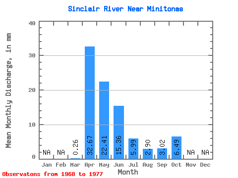
| Statistic | Jan | Feb | Mar | Apr | May | Jun | Jul | Aug | Sep | Oct | Nov | Dec | Annual |
|---|---|---|---|---|---|---|---|---|---|---|---|---|---|
| Mean | 0.26 | 32.68 | 22.41 | 15.36 | 5.99 | 2.90 | 3.02 | 6.49 | |||||
| Standard Deviation | 0.49 | 25.13 | 23.06 | 14.22 | 6.16 | 3.69 | 4.65 | 7.87 | |||||
| Min | 0.00 | 1.25 | 1.44 | 0.53 | 0.61 | 0.01 | 0.00 | 0.00 | |||||
| Max | 1.47 | 70.81 | 70.03 | 37.05 | 17.76 | 11.87 | 15.14 | 23.10 | |||||
| Coefficient of Variation | 1.88 | 0.77 | 1.03 | 0.93 | 1.03 | 1.27 | 1.54 | 1.21 |
 Return to R-Arctic Net Home Page