|
|
|||||||||||||||||
| Point ID: 2800 | Downloads | Plots | Site Data | Code: 05LE005 |
|
|
|||||||||||||||||
| Download | |
|---|---|
| Site Descriptor Information | Site Time Series Data |
| Link to all available data | |
| View: | Time Series | All |
| Units: | mm |
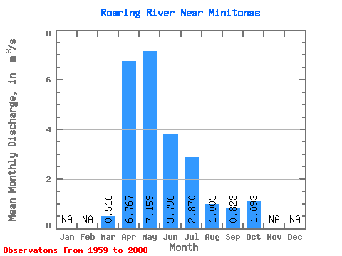
| Statistic | Jan | Feb | Mar | Apr | May | Jun | Jul | Aug | Sep | Oct | Nov | Dec | Annual |
|---|---|---|---|---|---|---|---|---|---|---|---|---|---|
| Mean | 0.52 | 6.77 | 7.16 | 3.80 | 2.87 | 1.00 | 0.82 | 1.09 | |||||
| Standard Deviation | 0.72 | 5.16 | 6.48 | 3.66 | 3.64 | 1.16 | 0.98 | 0.95 | |||||
| Min | 0.00 | 0.44 | 0.78 | 0.15 | 0.01 | 0.00 | 0.00 | 0.00 | |||||
| Max | 3.52 | 22.80 | 29.40 | 21.40 | 16.90 | 4.87 | 4.38 | 3.33 | |||||
| Coefficient of Variation | 1.41 | 0.76 | 0.91 | 0.96 | 1.27 | 1.15 | 1.19 | 0.87 |
 Return to R-Arctic Net Home Page