|
|
|||||||||||||||||
| Point ID: 2800 | Downloads | Plots | Site Data | Code: 05LE005 |
|
|
|||||||||||||||||
| Download | |
|---|---|
| Site Descriptor Information | Site Time Series Data |
| Link to all available data | |
| View: | Time Series | All |
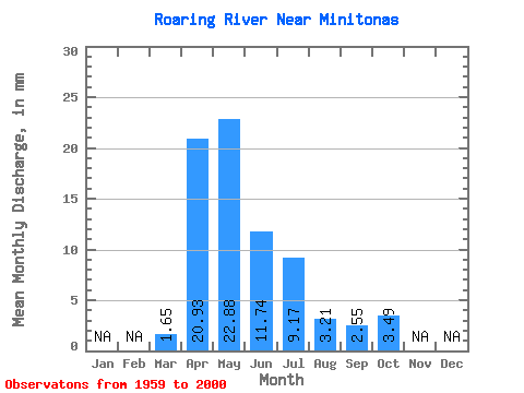
| Units: | m3/s |
| Statistic | Jan | Feb | Mar | Apr | May | Jun | Jul | Aug | Sep | Oct | Nov | Dec | Annual |
|---|---|---|---|---|---|---|---|---|---|---|---|---|---|
| Mean | 1.65 | 20.93 | 22.88 | 11.74 | 9.17 | 3.20 | 2.54 | 3.49 | |||||
| Standard Deviation | 2.32 | 15.96 | 20.71 | 11.33 | 11.63 | 3.69 | 3.03 | 3.03 | |||||
| Min | 0.00 | 1.37 | 2.50 | 0.46 | 0.03 | 0.00 | 0.00 | 0.01 | |||||
| Max | 11.25 | 70.52 | 93.95 | 66.19 | 54.01 | 15.56 | 13.55 | 10.64 | |||||
| Coefficient of Variation | 1.41 | 0.76 | 0.91 | 0.96 | 1.27 | 1.15 | 1.19 | 0.87 |
 Return to R-Arctic Net Home Page