|
|
|||||||||||||||||
| Point ID: 28 | Downloads | Plots | Site Data | Code: 05AB005 |
|
|
|||||||||||||||||
| Download | |
|---|---|
| Site Descriptor Information | Site Time Series Data |
| Link to all available data | |
| View: | Time Series | All |
| Units: | mm |
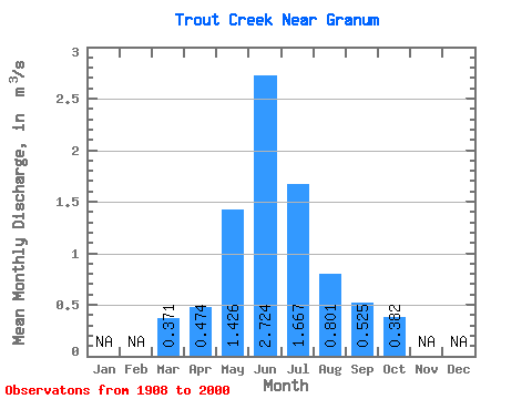
| Statistic | Jan | Feb | Mar | Apr | May | Jun | Jul | Aug | Sep | Oct | Nov | Dec | Annual |
|---|---|---|---|---|---|---|---|---|---|---|---|---|---|
| Mean | 0.37 | 0.47 | 1.43 | 2.72 | 1.67 | 0.80 | 0.53 | 0.38 | |||||
| Standard Deviation | 0.38 | 0.38 | 1.80 | 3.77 | 2.52 | 1.24 | 0.84 | 0.48 | |||||
| Min | 0.06 | 0.04 | 0.00 | 0.01 | 0.00 | 0.00 | 0.00 | 0.00 | |||||
| Max | 1.22 | 1.30 | 8.74 | 14.80 | 9.76 | 6.72 | 3.89 | 2.28 | |||||
| Coefficient of Variation | 1.03 | 0.80 | 1.26 | 1.38 | 1.51 | 1.54 | 1.59 | 1.25 |
 Return to R-Arctic Net Home Page