|
|
|||||||||||||||||
| Point ID: 28 | Downloads | Plots | Site Data | Code: 05AB005 |
|
|
|||||||||||||||||
| Download | |
|---|---|
| Site Descriptor Information | Site Time Series Data |
| Link to all available data | |
| View: | Time Series | All |
| Units: | m3/s |
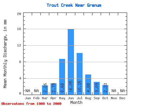
| Statistic | Jan | Feb | Mar | Apr | May | Jun | Jul | Aug | Sep | Oct | Nov | Dec | Annual |
|---|---|---|---|---|---|---|---|---|---|---|---|---|---|
| Mean | 2.26 | 2.79 | 8.68 | 16.05 | 10.14 | 4.88 | 3.09 | 2.33 | |||||
| Standard Deviation | 2.32 | 2.22 | 10.93 | 22.18 | 15.36 | 7.54 | 4.93 | 2.90 | |||||
| Min | 0.34 | 0.27 | 0.02 | 0.05 | 0.00 | 0.00 | 0.00 | 0.00 | |||||
| Max | 7.42 | 7.66 | 53.20 | 87.19 | 59.40 | 40.90 | 22.92 | 13.88 | |||||
| Coefficient of Variation | 1.03 | 0.80 | 1.26 | 1.38 | 1.51 | 1.54 | 1.59 | 1.25 |
 Return to R-Arctic Net Home Page