|
|
|||||||||||||||||
| Point ID: 2799 | Downloads | Plots | Site Data | Code: 05LE004 |
|
|
|||||||||||||||||
| Download | |
|---|---|
| Site Descriptor Information | Site Time Series Data |
| Link to all available data | |
| View: | Time Series | All |
| Units: | mm |
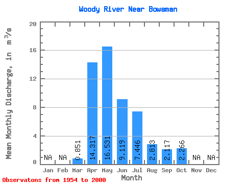
| Statistic | Jan | Feb | Mar | Apr | May | Jun | Jul | Aug | Sep | Oct | Nov | Dec | Annual |
|---|---|---|---|---|---|---|---|---|---|---|---|---|---|
| Mean | 0.85 | 14.32 | 16.53 | 9.12 | 7.45 | 2.81 | 2.12 | 2.27 | |||||
| Standard Deviation | 1.35 | 11.55 | 14.37 | 9.07 | 9.27 | 4.16 | 2.73 | 2.10 | |||||
| Min | 0.00 | 0.68 | 1.43 | 0.39 | 0.09 | 0.00 | 0.00 | 0.01 | |||||
| Max | 7.95 | 52.20 | 59.70 | 51.40 | 49.30 | 22.00 | 10.90 | 8.20 | |||||
| Coefficient of Variation | 1.59 | 0.81 | 0.87 | 0.99 | 1.24 | 1.48 | 1.29 | 0.93 |
 Return to R-Arctic Net Home Page