|
|
|||||||||||||||||
| Point ID: 2799 | Downloads | Plots | Site Data | Code: 05LE004 |
|
|
|||||||||||||||||
| Download | |
|---|---|
| Site Descriptor Information | Site Time Series Data |
| Link to all available data | |
| View: | Time Series | All |
| Units: | m3/s |
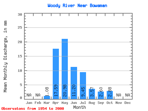
| Statistic | Jan | Feb | Mar | Apr | May | Jun | Jul | Aug | Sep | Oct | Nov | Dec | Annual |
|---|---|---|---|---|---|---|---|---|---|---|---|---|---|
| Mean | 1.08 | 17.59 | 20.98 | 11.20 | 9.45 | 3.57 | 2.60 | 2.88 | |||||
| Standard Deviation | 1.71 | 14.19 | 18.24 | 11.15 | 11.76 | 5.29 | 3.36 | 2.67 | |||||
| Min | 0.00 | 0.83 | 1.81 | 0.48 | 0.11 | 0.00 | 0.00 | 0.01 | |||||
| Max | 10.09 | 64.12 | 75.77 | 63.14 | 62.57 | 27.92 | 13.39 | 10.41 | |||||
| Coefficient of Variation | 1.59 | 0.81 | 0.87 | 0.99 | 1.24 | 1.48 | 1.29 | 0.93 |
 Return to R-Arctic Net Home Page