|
|
|||||||||||||||||
| Point ID: 2797 | Downloads | Plots | Site Data | Code: 05LE002 |
|
|
|||||||||||||||||
| Download | |
|---|---|
| Site Descriptor Information | Site Time Series Data |
| Link to all available data | |
| View: | Time Series | All |
| Units: | mm |
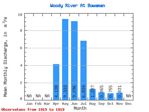
| Statistic | Jan | Feb | Mar | Apr | May | Jun | Jul | Aug | Sep | Oct | Nov | Dec | Annual |
|---|---|---|---|---|---|---|---|---|---|---|---|---|---|
| Mean | 4.14 | 9.33 | 9.10 | 6.83 | 1.29 | 0.86 | 0.76 | 0.83 | |||||
| Standard Deviation | 1.97 | 8.52 | 9.44 | 4.23 | 0.68 | 0.81 | 0.71 | 0.50 | |||||
| Min | 1.59 | 3.44 | 0.97 | 2.16 | 0.70 | 0.22 | 0.20 | 0.28 | |||||
| Max | 6.15 | 21.60 | 23.90 | 12.10 | 2.45 | 2.28 | 1.80 | 1.27 | |||||
| Coefficient of Variation | 0.48 | 0.91 | 1.04 | 0.62 | 0.53 | 0.94 | 0.95 | 0.60 |
 Return to R-Arctic Net Home Page