|
|
|||||||||||||||||
| Point ID: 2797 | Downloads | Plots | Site Data | Code: 05LE002 |
|
|
|||||||||||||||||
| Download | |
|---|---|
| Site Descriptor Information | Site Time Series Data |
| Link to all available data | |
| View: | Time Series | All |
| Units: | m3/s |
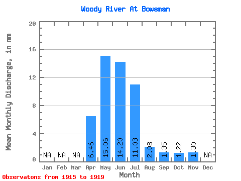
| Statistic | Jan | Feb | Mar | Apr | May | Jun | Jul | Aug | Sep | Oct | Nov | Dec | Annual |
|---|---|---|---|---|---|---|---|---|---|---|---|---|---|
| Mean | 6.46 | 15.06 | 14.20 | 11.03 | 2.08 | 1.35 | 1.22 | 1.30 | |||||
| Standard Deviation | 3.08 | 13.75 | 14.74 | 6.83 | 1.10 | 1.26 | 1.15 | 0.78 | |||||
| Min | 2.48 | 5.55 | 1.52 | 3.48 | 1.14 | 0.34 | 0.32 | 0.44 | |||||
| Max | 9.60 | 34.85 | 37.32 | 19.52 | 3.95 | 3.56 | 2.90 | 1.98 | |||||
| Coefficient of Variation | 0.48 | 0.91 | 1.04 | 0.62 | 0.53 | 0.94 | 0.95 | 0.60 |
 Return to R-Arctic Net Home Page