|
|
|||||||||||||||||
| Point ID: 2781 | Downloads | Plots | Site Data | Code: 10CD005 |
|
|
|||||||||||||||||
| Download | |
|---|---|
| Site Descriptor Information | Site Time Series Data |
| Link to all available data | |
| View: | Time Series | All |
| Units: | mm |
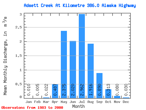
| Statistic | Jan | Feb | Mar | Apr | May | Jun | Jul | Aug | Sep | Oct | Nov | Dec | Annual |
|---|---|---|---|---|---|---|---|---|---|---|---|---|---|
| Mean | 0.01 | 0.01 | 0.02 | 0.49 | 2.38 | 2.02 | 2.96 | 1.92 | 0.89 | 0.31 | 0.08 | 0.03 | 0.94 |
| Standard Deviation | 0.02 | 0.01 | 0.04 | 0.45 | 1.67 | 1.23 | 4.73 | 2.25 | 1.01 | 0.27 | 0.07 | 0.03 | 0.47 |
| Min | 0.00 | 0.00 | 0.00 | 0.00 | 0.32 | 0.53 | 0.15 | 0.10 | 0.06 | 0.05 | 0.01 | 0.00 | 0.33 |
| Max | 0.05 | 0.02 | 0.12 | 1.55 | 5.68 | 5.25 | 20.70 | 8.03 | 3.38 | 0.93 | 0.24 | 0.10 | 2.02 |
| Coefficient of Variation | 1.57 | 1.48 | 1.81 | 0.92 | 0.70 | 0.61 | 1.60 | 1.17 | 1.13 | 0.85 | 0.88 | 1.07 | 0.50 |
 Return to R-Arctic Net Home Page