|
|
|||||||||||||||||
| Point ID: 2781 | Downloads | Plots | Site Data | Code: 10CD005 |
|
|
|||||||||||||||||
| Download | |
|---|---|
| Site Descriptor Information | Site Time Series Data |
| Link to all available data | |
| View: | Time Series | All |
| Units: | m3/s |
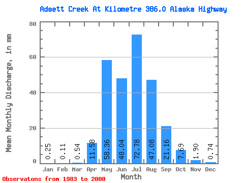
| Statistic | Jan | Feb | Mar | Apr | May | Jun | Jul | Aug | Sep | Oct | Nov | Dec | Annual |
|---|---|---|---|---|---|---|---|---|---|---|---|---|---|
| Mean | 0.25 | 0.12 | 0.54 | 11.58 | 58.35 | 48.03 | 72.77 | 47.07 | 21.18 | 7.70 | 1.90 | 0.74 | 271.68 |
| Standard Deviation | 0.39 | 0.17 | 0.97 | 10.68 | 41.06 | 29.16 | 116.11 | 55.23 | 24.00 | 6.52 | 1.67 | 0.79 | 134.95 |
| Min | 0.00 | 0.00 | 0.00 | 0.07 | 7.94 | 12.70 | 3.64 | 2.36 | 1.45 | 1.28 | 0.12 | 0.00 | 94.97 |
| Max | 1.30 | 0.54 | 3.07 | 36.86 | 139.55 | 124.84 | 508.57 | 197.29 | 80.38 | 22.82 | 5.68 | 2.58 | 583.72 |
| Coefficient of Variation | 1.57 | 1.48 | 1.81 | 0.92 | 0.70 | 0.61 | 1.60 | 1.17 | 1.13 | 0.85 | 0.88 | 1.07 | 0.50 |
 Return to R-Arctic Net Home Page