|
|
|||||||||||||||||
| Point ID: 2780 | Downloads | Plots | Site Data | Code: 10CD004 |
|
|
|||||||||||||||||
| Download | |
|---|---|
| Site Descriptor Information | Site Time Series Data |
| Link to all available data | |
| View: | Time Series | All |
| Units: | mm |
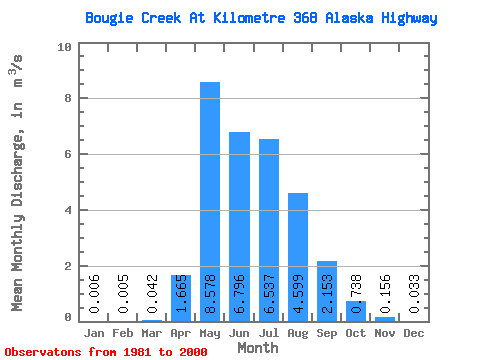
| Statistic | Jan | Feb | Mar | Apr | May | Jun | Jul | Aug | Sep | Oct | Nov | Dec | Annual |
|---|---|---|---|---|---|---|---|---|---|---|---|---|---|
| Mean | 0.01 | 0.01 | 0.04 | 1.67 | 8.58 | 6.80 | 6.54 | 4.60 | 2.15 | 0.74 | 0.16 | 0.03 | 2.63 |
| Standard Deviation | 0.01 | 0.01 | 0.11 | 1.96 | 5.30 | 3.99 | 5.48 | 5.62 | 2.77 | 0.74 | 0.15 | 0.04 | 0.96 |
| Min | 0.00 | 0.00 | 0.00 | 0.01 | 0.51 | 1.43 | 0.40 | 0.23 | 0.08 | 0.00 | 0.00 | 0.00 | 1.34 |
| Max | 0.05 | 0.06 | 0.43 | 7.22 | 17.30 | 14.90 | 21.70 | 21.00 | 9.44 | 2.40 | 0.56 | 0.13 | 5.01 |
| Coefficient of Variation | 2.10 | 2.88 | 2.59 | 1.18 | 0.62 | 0.59 | 0.84 | 1.22 | 1.29 | 1.00 | 0.94 | 1.34 | 0.36 |
 Return to R-Arctic Net Home Page