|
|
|||||||||||||||||
| Point ID: 2780 | Downloads | Plots | Site Data | Code: 10CD004 |
|
|
|||||||||||||||||
| Download | |
|---|---|
| Site Descriptor Information | Site Time Series Data |
| Link to all available data | |
| View: | Time Series | All |
| Units: | m3/s |
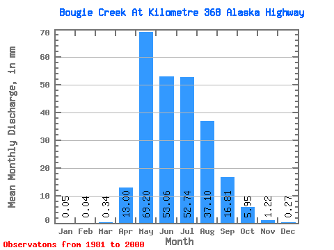
| Statistic | Jan | Feb | Mar | Apr | May | Jun | Jul | Aug | Sep | Oct | Nov | Dec | Annual |
|---|---|---|---|---|---|---|---|---|---|---|---|---|---|
| Mean | 0.05 | 0.04 | 0.34 | 13.00 | 69.19 | 53.06 | 52.73 | 37.09 | 16.81 | 5.96 | 1.22 | 0.27 | 249.71 |
| Standard Deviation | 0.10 | 0.10 | 0.88 | 15.31 | 42.73 | 31.12 | 44.22 | 45.33 | 21.66 | 5.93 | 1.14 | 0.36 | 90.99 |
| Min | 0.00 | 0.00 | 0.00 | 0.07 | 4.10 | 11.16 | 3.24 | 1.89 | 0.60 | 0.03 | 0.02 | 0.00 | 127.00 |
| Max | 0.40 | 0.43 | 3.44 | 56.37 | 139.55 | 116.33 | 175.04 | 169.39 | 73.70 | 19.36 | 4.37 | 1.02 | 476.18 |
| Coefficient of Variation | 2.10 | 2.88 | 2.59 | 1.18 | 0.62 | 0.59 | 0.84 | 1.22 | 1.29 | 1.00 | 0.94 | 1.34 | 0.36 |
 Return to R-Arctic Net Home Page