|
|
|||||||||||||||||
| Point ID: 278 | Downloads | Plots | Site Data | Code: 05BG006 |
|
|
|||||||||||||||||
| Download | |
|---|---|
| Site Descriptor Information | Site Time Series Data |
| Link to all available data | |
| View: | Time Series | All |
| Units: | mm |
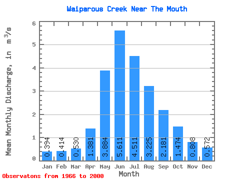
| Statistic | Jan | Feb | Mar | Apr | May | Jun | Jul | Aug | Sep | Oct | Nov | Dec | Annual |
|---|---|---|---|---|---|---|---|---|---|---|---|---|---|
| Mean | 0.39 | 0.41 | 0.53 | 1.38 | 3.88 | 5.61 | 4.51 | 3.23 | 2.18 | 1.47 | 0.81 | 0.57 | 2.04 |
| Standard Deviation | 0.15 | 0.15 | 0.19 | 0.56 | 2.15 | 3.27 | 3.39 | 2.31 | 1.14 | 0.74 | 0.29 | 0.18 | 0.79 |
| Min | 0.12 | 0.07 | 0.20 | 0.67 | 1.14 | 1.24 | 1.00 | 0.84 | 0.88 | 0.30 | 0.39 | 0.22 | 0.93 |
| Max | 0.71 | 0.76 | 1.01 | 3.52 | 8.60 | 13.70 | 13.60 | 12.20 | 6.28 | 4.79 | 1.63 | 1.02 | 4.34 |
| Coefficient of Variation | 0.38 | 0.36 | 0.35 | 0.41 | 0.55 | 0.58 | 0.75 | 0.71 | 0.52 | 0.50 | 0.36 | 0.32 | 0.39 |
 Return to R-Arctic Net Home Page