|
|
|||||||||||||||||
| Point ID: 278 | Downloads | Plots | Site Data | Code: 05BG006 |
|
|
|||||||||||||||||
| Download | |
|---|---|
| Site Descriptor Information | Site Time Series Data |
| Link to all available data | |
| View: | Time Series | All |
| Units: | m3/s |
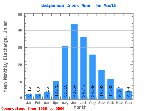
| Statistic | Jan | Feb | Mar | Apr | May | Jun | Jul | Aug | Sep | Oct | Nov | Dec | Annual |
|---|---|---|---|---|---|---|---|---|---|---|---|---|---|
| Mean | 3.15 | 3.02 | 4.25 | 10.71 | 31.14 | 43.54 | 36.17 | 25.86 | 16.93 | 11.82 | 6.27 | 4.59 | 192.58 |
| Standard Deviation | 1.19 | 1.09 | 1.51 | 4.34 | 17.26 | 25.42 | 27.16 | 18.48 | 8.82 | 5.94 | 2.23 | 1.46 | 74.51 |
| Min | 0.92 | 0.55 | 1.60 | 5.18 | 9.14 | 9.62 | 8.02 | 6.73 | 6.82 | 2.41 | 3.03 | 1.75 | 87.62 |
| Max | 5.69 | 5.57 | 8.10 | 27.32 | 68.95 | 106.32 | 109.04 | 97.82 | 48.74 | 38.41 | 12.65 | 8.18 | 409.89 |
| Coefficient of Variation | 0.38 | 0.36 | 0.35 | 0.41 | 0.55 | 0.58 | 0.75 | 0.71 | 0.52 | 0.50 | 0.36 | 0.32 | 0.39 |
 Return to R-Arctic Net Home Page