|
|
|||||||||||||||||
| Point ID: 2779 | Downloads | Plots | Site Data | Code: 10CD003 |
|
|
|||||||||||||||||
| Download | |
|---|---|
| Site Descriptor Information | Site Time Series Data |
| Link to all available data | |
| View: | Time Series | All |
| Units: | mm |
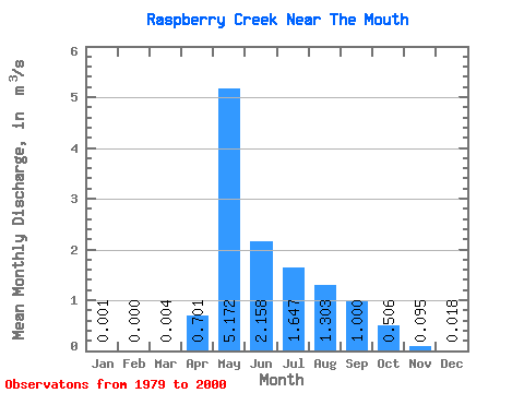
| Statistic | Jan | Feb | Mar | Apr | May | Jun | Jul | Aug | Sep | Oct | Nov | Dec | Annual |
|---|---|---|---|---|---|---|---|---|---|---|---|---|---|
| Mean | 0.00 | 0.00 | 0.00 | 0.70 | 5.17 | 2.16 | 1.65 | 1.30 | 1.00 | 0.51 | 0.10 | 0.02 | 1.05 |
| Standard Deviation | 0.00 | 0.00 | 0.01 | 0.89 | 3.89 | 1.66 | 1.98 | 1.82 | 1.22 | 0.62 | 0.12 | 0.04 | 0.53 |
| Min | 0.00 | 0.00 | 0.00 | 0.01 | 1.12 | 0.45 | 0.09 | 0.01 | 0.01 | 0.03 | 0.01 | 0.00 | 0.30 |
| Max | 0.01 | 0.00 | 0.04 | 3.43 | 14.90 | 7.09 | 8.98 | 8.10 | 4.99 | 2.29 | 0.45 | 0.15 | 2.08 |
| Coefficient of Variation | 1.78 | 2.94 | 2.12 | 1.27 | 0.75 | 0.77 | 1.21 | 1.40 | 1.22 | 1.22 | 1.30 | 2.06 | 0.50 |
 Return to R-Arctic Net Home Page