|
|
|||||||||||||||||
| Point ID: 2779 | Downloads | Plots | Site Data | Code: 10CD003 |
|
|
|||||||||||||||||
| Download | |
|---|---|
| Site Descriptor Information | Site Time Series Data |
| Link to all available data | |
| View: | Time Series | All |
| Units: | m3/s |
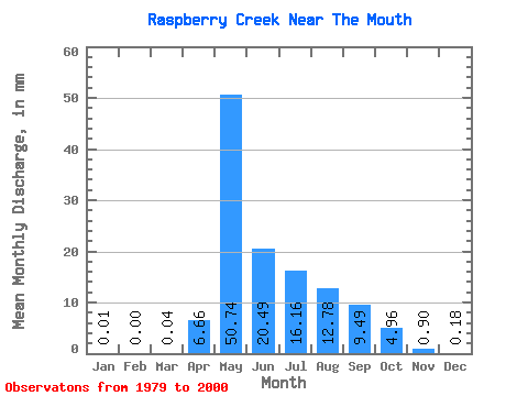
| Statistic | Jan | Feb | Mar | Apr | May | Jun | Jul | Aug | Sep | Oct | Nov | Dec | Annual |
|---|---|---|---|---|---|---|---|---|---|---|---|---|---|
| Mean | 0.01 | 0.00 | 0.04 | 6.65 | 50.74 | 20.49 | 16.16 | 12.78 | 9.50 | 4.97 | 0.90 | 0.17 | 121.31 |
| Standard Deviation | 0.02 | 0.01 | 0.09 | 8.46 | 38.12 | 15.80 | 19.46 | 17.91 | 11.61 | 6.05 | 1.17 | 0.36 | 61.19 |
| Min | 0.00 | 0.00 | 0.00 | 0.06 | 10.99 | 4.29 | 0.88 | 0.11 | 0.07 | 0.27 | 0.06 | 0.00 | 35.20 |
| Max | 0.05 | 0.03 | 0.40 | 32.57 | 146.16 | 67.32 | 88.09 | 79.46 | 47.38 | 22.46 | 4.31 | 1.45 | 239.99 |
| Coefficient of Variation | 1.78 | 2.94 | 2.12 | 1.27 | 0.75 | 0.77 | 1.21 | 1.40 | 1.22 | 1.22 | 1.30 | 2.06 | 0.50 |
 Return to R-Arctic Net Home Page