|
|
|||||||||||||||||
| Point ID: 2769 | Downloads | Plots | Site Data | Code: 10BE010 |
|
|
|||||||||||||||||
| Download | |
|---|---|
| Site Descriptor Information | Site Time Series Data |
| Link to all available data | |
| View: | Time Series | All |
| Units: | mm |
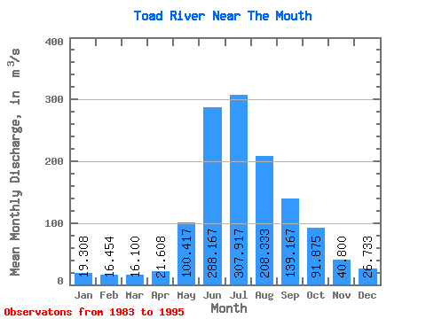
| Statistic | Jan | Feb | Mar | Apr | May | Jun | Jul | Aug | Sep | Oct | Nov | Dec | Annual |
|---|---|---|---|---|---|---|---|---|---|---|---|---|---|
| Mean | 19.31 | 16.45 | 16.10 | 21.61 | 100.42 | 288.17 | 307.92 | 208.33 | 139.17 | 91.88 | 40.80 | 26.73 | 106.41 |
| Standard Deviation | 5.33 | 2.62 | 2.25 | 4.24 | 35.53 | 52.46 | 106.24 | 69.67 | 52.44 | 31.68 | 14.02 | 10.32 | 17.64 |
| Min | 11.00 | 12.30 | 12.60 | 14.90 | 57.30 | 209.00 | 198.00 | 113.00 | 69.50 | 47.80 | 20.50 | 15.20 | 78.14 |
| Max | 29.40 | 20.70 | 20.80 | 28.60 | 169.00 | 361.00 | 543.00 | 338.00 | 260.00 | 158.00 | 75.30 | 51.40 | 135.66 |
| Coefficient of Variation | 0.28 | 0.16 | 0.14 | 0.20 | 0.35 | 0.18 | 0.34 | 0.33 | 0.38 | 0.34 | 0.34 | 0.39 | 0.17 |
 Return to R-Arctic Net Home Page