|
|
|||||||||||||||||
| Point ID: 2769 | Downloads | Plots | Site Data | Code: 10BE010 |
|
|
|||||||||||||||||
| Download | |
|---|---|
| Site Descriptor Information | Site Time Series Data |
| Link to all available data | |
| View: | Time Series | All |
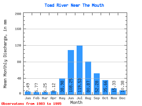
| Units: | m3/s |
| Statistic | Jan | Feb | Mar | Apr | May | Jun | Jul | Aug | Sep | Oct | Nov | Dec | Annual |
|---|---|---|---|---|---|---|---|---|---|---|---|---|---|
| Mean | 7.49 | 5.82 | 6.25 | 8.12 | 38.97 | 108.25 | 119.51 | 80.86 | 52.28 | 35.66 | 15.33 | 10.38 | 486.69 |
| Standard Deviation | 2.07 | 0.93 | 0.87 | 1.59 | 13.79 | 19.70 | 41.23 | 27.04 | 19.70 | 12.30 | 5.27 | 4.01 | 80.69 |
| Min | 4.27 | 4.35 | 4.89 | 5.60 | 22.24 | 78.51 | 76.85 | 43.86 | 26.11 | 18.55 | 7.70 | 5.90 | 357.41 |
| Max | 11.41 | 7.32 | 8.07 | 10.74 | 65.59 | 135.61 | 210.75 | 131.18 | 97.67 | 61.32 | 28.29 | 19.95 | 620.49 |
| Coefficient of Variation | 0.28 | 0.16 | 0.14 | 0.20 | 0.35 | 0.18 | 0.34 | 0.33 | 0.38 | 0.34 | 0.34 | 0.39 | 0.17 |
 Return to R-Arctic Net Home Page