|
|
|||||||||||||||||
| Point ID: 2765 | Downloads | Plots | Site Data | Other Close Sites | Code: 10BE006 |
|
|
|||||||||||||||||
| Download | |
|---|---|
| Site Descriptor Information | Site Time Series Data |
| Link to all available data | |
| View: | Time Series | All |
| Units: | mm |
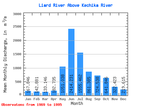
| Statistic | Jan | Feb | Mar | Apr | May | Jun | Jul | Aug | Sep | Oct | Nov | Dec | Annual |
|---|---|---|---|---|---|---|---|---|---|---|---|---|---|
| Mean | 167.85 | 142.88 | 133.15 | 182.74 | 1051.04 | 2414.23 | 1555.46 | 861.38 | 724.54 | 641.85 | 322.42 | 219.62 | 706.15 |
| Standard Deviation | 34.29 | 27.40 | 26.07 | 86.32 | 283.98 | 530.47 | 451.27 | 186.04 | 152.17 | 176.11 | 76.08 | 47.03 | 91.47 |
| Min | 115.00 | 98.90 | 85.70 | 93.10 | 579.00 | 1370.00 | 857.00 | 541.00 | 403.00 | 422.00 | 217.00 | 148.00 | 502.23 |
| Max | 264.00 | 204.00 | 197.00 | 514.00 | 1620.00 | 3620.00 | 2410.00 | 1320.00 | 1190.00 | 1020.00 | 555.00 | 367.00 | 881.50 |
| Coefficient of Variation | 0.20 | 0.19 | 0.20 | 0.47 | 0.27 | 0.22 | 0.29 | 0.22 | 0.21 | 0.27 | 0.24 | 0.21 | 0.13 |
| Other Close Sites | ||||||
|---|---|---|---|---|---|---|
| PointID | Latitude | Longitude | Drainage Area | Source | Name | |
| 2758 | "KECHIKA RIVER AT THE MOUTH" | 59.61 | 2024381 | Hydat | ||
 Return to R-Arctic Net Home Page