|
|
|||||||||||||||||
| Point ID: 2758 | Downloads | Plots | Site Data | Other Close Sites | Code: 10BB001 |
|
|
|||||||||||||||||
| Download | |
|---|---|
| Site Descriptor Information | Site Time Series Data |
| Link to all available data | |
| View: | Time Series | All |
| Units: | mm |
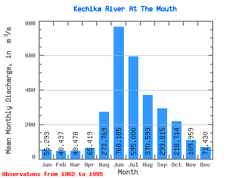
| Statistic | Jan | Feb | Mar | Apr | May | Jun | Jul | Aug | Sep | Oct | Nov | Dec | Annual |
|---|---|---|---|---|---|---|---|---|---|---|---|---|---|
| Mean | 55.29 | 48.44 | 48.48 | 65.42 | 273.77 | 768.18 | 595.00 | 370.59 | 293.81 | 218.71 | 109.96 | 71.43 | 244.75 |
| Standard Deviation | 9.01 | 8.96 | 10.33 | 18.85 | 100.15 | 173.80 | 162.35 | 76.60 | 60.79 | 53.64 | 21.46 | 11.60 | 25.52 |
| Min | 40.10 | 27.70 | 26.50 | 37.80 | 122.00 | 528.00 | 292.00 | 257.00 | 179.00 | 153.00 | 78.60 | 55.50 | 180.05 |
| Max | 70.80 | 65.10 | 76.60 | 124.00 | 573.00 | 1250.00 | 909.00 | 581.00 | 396.00 | 370.00 | 168.00 | 110.00 | 280.24 |
| Coefficient of Variation | 0.16 | 0.18 | 0.21 | 0.29 | 0.37 | 0.23 | 0.27 | 0.21 | 0.21 | 0.24 | 0.20 | 0.16 | 0.10 |
| Other Close Sites | ||||||
|---|---|---|---|---|---|---|
| PointID | Latitude | Longitude | Drainage Area | Source | Name | |
| 2765 | "LIARD RIVER ABOVE KECHIKA RIVER" | 59.70 | 2014363 | Hydat | ||
 Return to R-Arctic Net Home Page