|
|
|||||||||||||||||
| Point ID: 2762 | Downloads | Plots | Site Data | Code: 10BE002 |
|
|
|||||||||||||||||
| Download | |
|---|---|
| Site Descriptor Information | Site Time Series Data |
| Link to all available data | |
| View: | Time Series | All |
| Units: | mm |
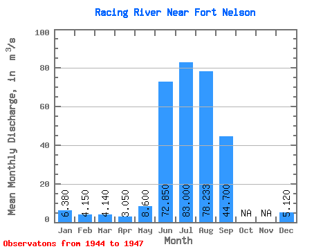
| Statistic | Jan | Feb | Mar | Apr | May | Jun | Jul | Aug | Sep | Oct | Nov | Dec | Annual |
|---|---|---|---|---|---|---|---|---|---|---|---|---|---|
| Mean | 6.38 | 4.15 | 4.14 | 3.05 | 8.60 | 72.85 | 83.00 | 78.23 | 44.70 | 5.12 | |||
| Standard Deviation | 27.79 | 2.40 | 7.09 | ||||||||||
| Min | 6.38 | 4.15 | 4.14 | 3.05 | 8.60 | 53.20 | 81.30 | 73.60 | 44.70 | 5.12 | |||
| Max | 6.38 | 4.15 | 4.14 | 3.05 | 8.60 | 92.50 | 84.70 | 86.40 | 44.70 | 5.12 | |||
| Coefficient of Variation | 0.38 | 0.03 | 0.09 |
 Return to R-Arctic Net Home Page