|
|
|||||||||||||||||
| Point ID: 2762 | Downloads | Plots | Site Data | Code: 10BE002 |
|
|
|||||||||||||||||
| Download | |
|---|---|
| Site Descriptor Information | Site Time Series Data |
| Link to all available data | |
| View: | Time Series | All |
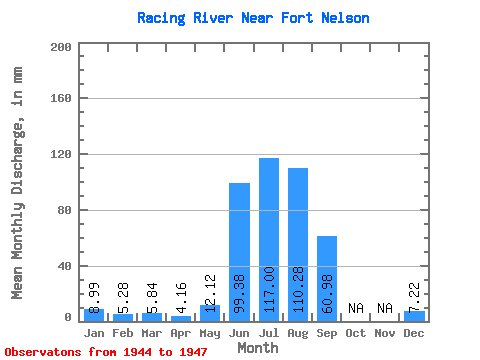
| Units: | m3/s |
| Statistic | Jan | Feb | Mar | Apr | May | Jun | Jul | Aug | Sep | Oct | Nov | Dec | Annual |
|---|---|---|---|---|---|---|---|---|---|---|---|---|---|
| Mean | 8.99 | 5.33 | 5.83 | 4.16 | 12.12 | 99.38 | 116.99 | 110.27 | 60.98 | 7.22 | |||
| Standard Deviation | 37.91 | 3.39 | 10.00 | ||||||||||
| Min | 8.99 | 5.33 | 5.83 | 4.16 | 12.12 | 72.58 | 114.59 | 103.74 | 60.98 | 7.22 | |||
| Max | 8.99 | 5.33 | 5.83 | 4.16 | 12.12 | 126.19 | 119.38 | 121.78 | 60.98 | 7.22 | |||
| Coefficient of Variation | 0.38 | 0.03 | 0.09 |
 Return to R-Arctic Net Home Page