|
|
|||||||||||||||||
| Point ID: 2748 | Downloads | Plots | Site Data | Code: 09AA015 |
|
|
|||||||||||||||||
| Download | |
|---|---|
| Site Descriptor Information | Site Time Series Data |
| Link to all available data | |
| View: | Time Series | All |
| Units: | mm |
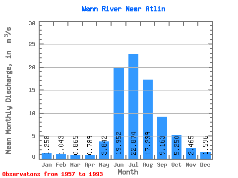
| Statistic | Jan | Feb | Mar | Apr | May | Jun | Jul | Aug | Sep | Oct | Nov | Dec | Annual |
|---|---|---|---|---|---|---|---|---|---|---|---|---|---|
| Mean | 1.26 | 1.04 | 0.86 | 0.79 | 3.84 | 19.95 | 22.87 | 17.24 | 9.16 | 5.25 | 2.46 | 1.60 | 7.12 |
| Standard Deviation | 0.23 | 0.21 | 0.19 | 0.17 | 2.66 | 5.09 | 4.47 | 3.45 | 3.31 | 2.19 | 0.88 | 0.36 | 0.96 |
| Min | 0.88 | 0.64 | 0.53 | 0.45 | 1.12 | 12.70 | 14.00 | 9.56 | 4.05 | 2.05 | 1.21 | 1.07 | 5.11 |
| Max | 1.79 | 1.54 | 1.35 | 1.29 | 12.40 | 30.00 | 31.70 | 24.20 | 19.70 | 11.10 | 4.79 | 2.33 | 9.02 |
| Coefficient of Variation | 0.18 | 0.20 | 0.22 | 0.21 | 0.69 | 0.26 | 0.20 | 0.20 | 0.36 | 0.42 | 0.36 | 0.23 | 0.14 |
 Return to R-Arctic Net Home Page