|
|
|||||||||||||||||
| Point ID: 2748 | Downloads | Plots | Site Data | Code: 09AA015 |
|
|
|||||||||||||||||
| Download | |
|---|---|
| Site Descriptor Information | Site Time Series Data |
| Link to all available data | |
| View: | Time Series | All |
| Units: | m3/s |
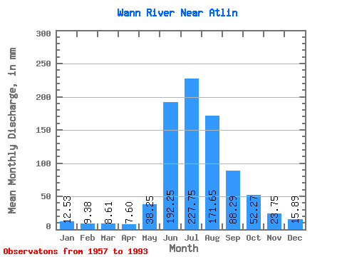
| Statistic | Jan | Feb | Mar | Apr | May | Jun | Jul | Aug | Sep | Oct | Nov | Dec | Annual |
|---|---|---|---|---|---|---|---|---|---|---|---|---|---|
| Mean | 12.52 | 9.46 | 8.61 | 7.61 | 38.25 | 192.25 | 227.72 | 171.62 | 88.29 | 52.26 | 23.75 | 15.88 | 835.03 |
| Standard Deviation | 2.25 | 1.94 | 1.90 | 1.59 | 26.47 | 49.04 | 44.51 | 34.32 | 31.90 | 21.84 | 8.45 | 3.63 | 112.62 |
| Min | 8.72 | 5.84 | 5.26 | 4.37 | 11.15 | 122.37 | 139.38 | 95.17 | 39.02 | 20.41 | 11.66 | 10.65 | 599.06 |
| Max | 17.82 | 13.97 | 13.44 | 12.43 | 123.45 | 289.07 | 315.59 | 240.92 | 189.82 | 110.50 | 46.16 | 23.20 | 1058.56 |
| Coefficient of Variation | 0.18 | 0.20 | 0.22 | 0.21 | 0.69 | 0.26 | 0.20 | 0.20 | 0.36 | 0.42 | 0.36 | 0.23 | 0.14 |
 Return to R-Arctic Net Home Page