|
|
|||||||||||||||||
| Point ID: 273 | Downloads | Plots | Site Data | Code: 05BG001 |
|
|
|||||||||||||||||
| Download | |
|---|---|
| Site Descriptor Information | Site Time Series Data |
| Link to all available data | |
| View: | Time Series | All |
| Units: | mm |
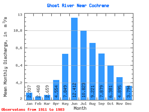
| Statistic | Jan | Feb | Mar | Apr | May | Jun | Jul | Aug | Sep | Oct | Nov | Dec | Annual |
|---|---|---|---|---|---|---|---|---|---|---|---|---|---|
| Mean | 2.94 | 2.47 | 2.66 | 4.55 | 7.85 | 12.41 | 10.82 | 9.22 | 7.88 | 6.38 | 4.89 | 3.79 | 6.29 |
| Standard Deviation | 0.79 | 0.62 | 0.90 | 2.23 | 4.71 | 10.43 | 6.90 | 4.39 | 3.72 | 2.33 | 1.47 | 1.09 | 2.48 |
| Min | 1.06 | 0.98 | 1.24 | 2.08 | 2.59 | 3.33 | 3.74 | 4.25 | 4.31 | 3.21 | 2.84 | 1.31 | 3.52 |
| Max | 5.55 | 4.42 | 6.93 | 16.50 | 27.50 | 60.10 | 41.20 | 27.90 | 23.40 | 16.00 | 9.24 | 6.90 | 14.29 |
| Coefficient of Variation | 0.27 | 0.25 | 0.34 | 0.49 | 0.60 | 0.84 | 0.64 | 0.48 | 0.47 | 0.36 | 0.30 | 0.29 | 0.39 |
 Return to R-Arctic Net Home Page