|
|
|||||||||||||||||
| Point ID: 273 | Downloads | Plots | Site Data | Code: 05BG001 |
|
|
|||||||||||||||||
| Download | |
|---|---|
| Site Descriptor Information | Site Time Series Data |
| Link to all available data | |
| View: | Time Series | All |
| Units: | m3/s |
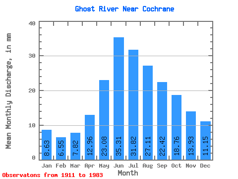
| Statistic | Jan | Feb | Mar | Apr | May | Jun | Jul | Aug | Sep | Oct | Nov | Dec | Annual |
|---|---|---|---|---|---|---|---|---|---|---|---|---|---|
| Mean | 8.63 | 6.61 | 7.81 | 12.96 | 23.07 | 35.31 | 31.81 | 27.11 | 22.42 | 18.76 | 13.93 | 11.15 | 218.07 |
| Standard Deviation | 2.33 | 1.65 | 2.65 | 6.34 | 13.85 | 29.67 | 20.28 | 12.91 | 10.59 | 6.84 | 4.17 | 3.22 | 85.73 |
| Min | 3.12 | 2.62 | 3.65 | 5.92 | 7.61 | 9.47 | 10.99 | 12.49 | 12.26 | 9.44 | 8.08 | 3.85 | 121.86 |
| Max | 16.32 | 11.84 | 20.37 | 46.95 | 80.84 | 171.00 | 121.11 | 82.02 | 66.58 | 47.03 | 26.29 | 20.28 | 495.11 |
| Coefficient of Variation | 0.27 | 0.25 | 0.34 | 0.49 | 0.60 | 0.84 | 0.64 | 0.48 | 0.47 | 0.36 | 0.30 | 0.29 | 0.39 |
 Return to R-Arctic Net Home Page