|
|
|||||||||||||||||
| Point ID: 272 | Downloads | Plots | Site Data | Code: 05BF025 |
|
|
|||||||||||||||||
| Download | |
|---|---|
| Site Descriptor Information | Site Time Series Data |
| Link to all available data | |
| View: | Time Series | All |
| Units: | mm |
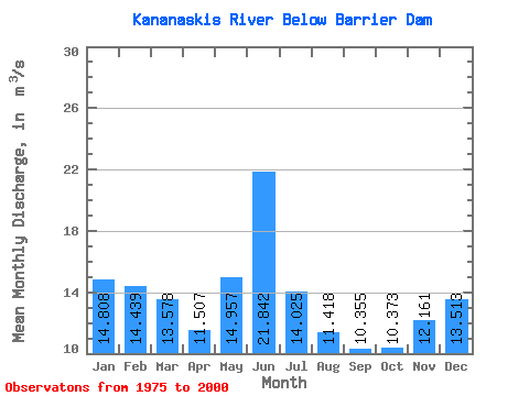
| Statistic | Jan | Feb | Mar | Apr | May | Jun | Jul | Aug | Sep | Oct | Nov | Dec | Annual |
|---|---|---|---|---|---|---|---|---|---|---|---|---|---|
| Mean | 14.81 | 14.44 | 13.58 | 11.51 | 14.96 | 21.84 | 14.03 | 11.42 | 10.36 | 10.37 | 12.16 | 13.51 | 13.58 |
| Standard Deviation | 2.88 | 2.79 | 3.53 | 4.78 | 5.16 | 11.06 | 6.94 | 4.25 | 3.29 | 2.74 | 3.71 | 3.09 | 2.48 |
| Min | 8.73 | 5.95 | 3.66 | 0.11 | 6.91 | 9.55 | 4.57 | 5.86 | 4.81 | 5.71 | 6.14 | 8.67 | 9.89 |
| Max | 21.20 | 20.80 | 19.80 | 20.20 | 24.80 | 50.00 | 29.20 | 19.90 | 18.30 | 15.80 | 20.10 | 24.00 | 18.92 |
| Coefficient of Variation | 0.19 | 0.19 | 0.26 | 0.41 | 0.34 | 0.51 | 0.49 | 0.37 | 0.32 | 0.26 | 0.30 | 0.23 | 0.18 |
 Return to R-Arctic Net Home Page